Toyozawa
| Toyozawa 豊沢 | ||
|---|---|---|
| Metropolis | ||
Toyozawa Metropolis | ||
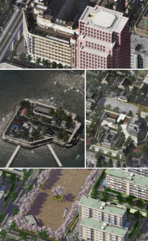
 Clockwise, from top: Kanda District, Toyozawa Castle,Apartment blocks at Haramaki New City, Jurakutei Island | ||
| ||
| Nickname(s): Island City, City of Temples, Nation's Kitchen | ||
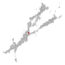
 Location of Toyozawa in Okaiken | ||
| Country |
| |
| Island | Yagikoshu | |
| Region | Miseto | |
| Divisions | 12 special wards, 2 cities, 1 district | |
| Government | ||
| • Type | Metropolis | |
| • Governor | Ikeda Ayato (I) | |
| • Capital | Toyozawa[1] | |
| Area | ||
| • Metropolis | 1,672.12 km2 (650 sq mi) | |
| • Metro | 6,533.1 km2 (2,500 sq mi) | |
| Area rank | 46th | |
| Population (August 1, 2011) | ||
| • Metropolis | 4,332,125 | |
| • Density | 2,600/km2 (6,700/sq mi) | |
| • Metro | 8,430,000 | |
| • Metro density | 1,300/km2 (3,300/sq mi) | |
| Demonym(s) | Toyozawan | |
| Time zone | Okaiken Standard Time (UTC+9) | |
| ISO 3166-2 | OK-13 | |
| Website | toyozawa.ok | |
Toyozawa (豊沢 Toyozawa) is a metropolis in the Miseto region of Okaiken. It is the largest component of the Misetogawa Metropolitan Area, the second largest metropolitan area in Okaiken and among the largest in the world with nearly 12 million inhabitants. Situated at the mouth of the Yodo River on Toyozawa Bay, Toyozawa is Okaiken's second largest city by the daytime population after Okami, and serves as a major economic hub.
Historically a merchant city, Toyozawa has also been known as the "nation's kitchen" (天下の台所 tenka no daidokoro) and served as a center for the rice trade during the Honda period.
Etymology[edit | edit source]
History[edit | edit source]
The history of Toyozawa is shaped by many conflicts it encountered. Being a primitive outpost for the Atsu people, it played a role with trade with the Miyagi empire inhabitants as well as foreigners. It later grew to a large settlement of around 2,300 before an attack by the primitive Miyagi citizens forced the Atsus to abandon the settlement and move further south into what is now Aomori prefecture.
Early period[edit | edit source]
Sengoku period[edit | edit source]
Honda period[edit | edit source]
After the death of Honda Shigetada in 1625, parts of the city was subsequently destroyed by a typhoon in 26 June, a day after the deaths of Honda Shigetomo and Ii Naotaka at the Battle of Ichijoudani. Parts of the city were subsequently rebuilt, including parts of the Kuroku ward, the Oyashio ward and the Namba ward. Parts of the burned remains of Toyozawa Castle, the Seien-ji temple and the Kyudo-jinja shirne were repurposed into a new commercial district called the Nishi Hattori Ward.
Modern Period[edit | edit source]
The modern municipality was established in 1889 by government ordinance, with an initial area of 15km², overlapping today's Chūō and Nanba wards. Later, the city went through three major expansions to reach its current size of 223km². Toyozawa was the industrial center most clearly defined in the development of capitalism in Okaiken.
The rapid industrialization attracted many Kwangju immigrants, who set up a life apart for themselves. The political system was pluralistic, with a strong emphasis on promoting industrialization and modernization. Literacy was high and the educational system expanded rapidly, producing a middle class with a taste for literature and a willingness to support the arts. In 1927, Daiso operated a factory that built cars for the Eastern Althenian continent, operated and staffed by Sanese workers and managers.
Like its Western Althenian and Neridean counterparts, Toyozawa displayed slums, unemployment, and poverty as similar to a favela. In Okaiken it was here that municipal government first introduced a comprehensive system of poverty relief, copied in part from Trent models. Toyozawa policymakers stressed the importance of family formation and mutual assistance as the best way to combat poverty. This minimized the cost of welfare programs.
Geography and Climate[edit | edit source]
Geography[edit | edit source]
Climate[edit | edit source]
| Climate data for Ōtemachi, Tennoji ward, Toyozawa (1981–2010) | |||||||||||||
|---|---|---|---|---|---|---|---|---|---|---|---|---|---|
| Month | Jan | Feb | Mar | Apr | May | Jun | Jul | Aug | Sep | Oct | Nov | Dec | Year |
| Record high °C (°F) | 22.6 (72.7) |
24.9 (76.8) |
25.3 (77.5) |
29.2 (84.6) |
32.2 (90) |
36.2 (97.2) |
39.5 (103.1) |
39.1 (102.4) |
38.1 (100.6) |
32.6 (90.7) |
27.3 (81.1) |
24.8 (76.6) |
39.5 (103.1) |
| Average high °C (°F) | 9.6 (49.3) |
10.4 (50.7) |
13.6 (56.5) |
19.0 (66.2) |
22.9 (73.2) |
25.5 (77.9) |
29.2 (84.6) |
30.8 (87.4) |
26.9 (80.4) |
21.5 (70.7) |
16.3 (61.3) |
11.9 (53.4) |
19.8 (67.6) |
| Daily mean °C (°F) | 5.2 (41.4) |
5.7 (42.3) |
8.7 (47.7) |
13.9 (57) |
18.2 (64.8) |
21.4 (70.5) |
25.0 (77) |
26.4 (79.5) |
22.8 (73) |
17.5 (63.5) |
12.1 (53.8) |
7.6 (45.7) |
15.4 (59.7) |
| Average low °C (°F) | 0.9 (33.6) |
1.7 (35.1) |
4.4 (39.9) |
9.4 (48.9) |
14.0 (57.2) |
18.0 (64.4) |
21.8 (71.2) |
23.0 (73.4) |
19.7 (67.5) |
14.2 (57.6) |
8.3 (46.9) |
3.5 (38.3) |
11.6 (52.9) |
| Record low °C (°F) | −9.2 (15.4) |
−7.9 (17.8) |
−5.6 (21.9) |
−3.1 (26.4) |
2.2 (36) |
8.5 (47.3) |
13.0 (55.4) |
15.4 (59.7) |
10.5 (50.9) |
−0.5 (31.1) |
−3.1 (26.4) |
−6.8 (19.8) |
−9.2 (15.4) |
| Average precipitation mm (inches) | 52.3 (2.059) |
56.1 (2.209) |
117.5 (4.626) |
124.5 (4.902) |
137.8 (5.425) |
167.7 (6.602) |
153.5 (6.043) |
168.2 (6.622) |
209.9 (8.264) |
197.8 (7.787) |
92.5 (3.642) |
51.0 (2.008) |
1,528.8 (60.189) |
| Average snowfall cm (inches) | 5 (2) |
5 (2) |
1 (0.4) |
0 (0) |
0 (0) |
0 (0) |
0 (0) |
0 (0) |
0 (0) |
0 (0) |
0 (0) |
0 (0) |
11 (4.3) |
| Average precipitation days (≥ 0.5 mm) | 5.3 | 6.2 | 11.0 | 11.0 | 11.4 | 12.7 | 11.8 | 9.0 | 12.2 | 10.8 | 7.6 | 4.9 | 114.0 |
| Average snowy days | 2.8 | 3.7 | 2.2 | 0.2 | 0.0 | 0.0 | 0.0 | 0.0 | 0.0 | 0.0 | 0.0 | 0.8 | 9.7 |
| Average relative humidity (%) | 52 | 53 | 56 | 62 | 69 | 75 | 77 | 73 | 75 | 68 | 65 | 56 | 62 |
| Mean monthly sunshine hours | 184.5 | 165.8 | 163.1 | 176.9 | 167.8 | 125.4 | 146.4 | 169.0 | 120.9 | 131.0 | 147.9 | 178.0 | 1,876.7 |
| [citation needed] | |||||||||||||
References[edit | edit source]
| ||||||||||||||||||||||||||||||||||||||||||||||||||||||||

